Environmental Geophysics - Survey, Research and Consultancy
+44 (0) 1989 477 020 |


Welcome to TigerGeo
Combined Environmental Geophysical, Topographical and Terrestrial LiDAR Services
Applications include:
- agricultural irrigation and drainage
- archaeological and palaeo-environmental sites
- depth to bedrock and overburden thickness
- detecting karst and solution features, cavities and sinkholes
- finding leaks and moisture within structures
- geological mapping, stratigraphic investigation
- groundwater supplies and drainage
- hidden services, cellars, voids and shallow mine workings
- historic gardens, landscapes and structures
- locating concrete reinforcement, hidden flues and steelwork
- mapping cemeteries, finding graves and vaults
- peat and wetland hydrology, extent and thickness
- topographic and landform mapping
News!
- We're moving office - please note the new 'phone number +44 (0) 1989 477 020
- We are pleased to be supporting COST Action CA17131
The Soil Science & Archaeo-Geophysics Alliance: going beyond prospection
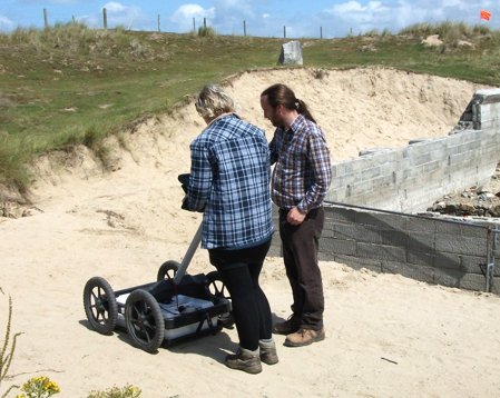
2D / 3D electrical resistivity tomography, electromagnetics, ground penetrating / wall probing radar, induced polarisation, magnetic susceptibility, MASW, micro-gravity, seismic reflection / refraction, terrestrial LiDAR, GNSS and total station topographic survey, total magnetic intensity


©TigerGeo Limited - Registered in England & Wales 09895326 - D-U-N-S 22-127-7456 - All Rights Reserved